Trail Mountain bike Wiler (Lötschen) - Wallis North 9 : Lauchernalp - Mund - Photo

Wallis North 9 : Lauchernalp - Mund

 ovronne
ovronne

User

© OpenStreetMap contributors
Length
Length
45 km
Max alt
Max alt
2140 m
Uphill gradient
Uphill gradient
1814 m
Km-Effort
Km-Effort  
72 km
Min alt
Min alt
642 m
Downhill gradient
Downhill gradient
2662 m
Boucle
Boucle
No
Creation date :
2014-12-10 00:00:00.0
Updated on :
2014-12-10 00:00:00.0

(0 Reviews)

Mountain bike
Mountain bike
5h46
Difficulty : Unknown

Scan this QR Code to open this trail in the SityTrail application

FREE GPS app for hiking

Logo SityTrail SityTrail

IGN / Geographical institutes

Download SityTrail from the App Store Download SityTrail from Google Play

Logo SityTrail SityTrail World

The world is yours!

Download SityTrail from the App Store Download SityTrail from Google Play Download SityTrail on Huawei AppGallery

About

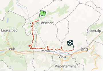
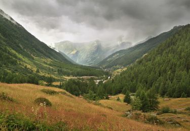
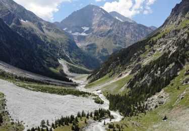
Trail Mountain bike of 45 km to be discovered at Valais/Wallis, Westlich Raron, Wiler (Lötschen). This trail is proposed by ovronne.

Elevation profile

Positioning

Country:
Switzerland
Region :
Valais/Wallis
Department/Province :
Westlich Raron
Municipality :
Wiler (Lötschen)
Location:
Unknown
Start:(UTM)
405430 ; 5140860 (32T) N.

Trails nearby

Trail On foot Kippel - Harrischfuhre - Goppenstein - Photo
On foot
PRO

On foot

Easy
Kippel, Valais/Wallis, Westlich Raron, Switzerland
3.1 km | 4.6 km-effort
1h 2min
No
Trail On foot Kandersteg - Gfelalp - Lötschenpass - Photo
On foot
PRO

On foot

Easy
Kandersteg, Bern, Frutigen-Niedersimmental administrative district, Switzerland
4.4 km | 12.7 km-effort
2h 53min
No
Trail On foot Ferden - Lötschentaler Höhenwanderweg - Photo
On foot
PRO

On foot

Easy
Ferden, Valais/Wallis, Westlich Raron, Switzerland
12 km | 17.2 km-effort
3h 54min
No
Trail On foot Blatten - Wiler-Blaten - Photo
On foot
PRO

On foot

Easy
Blatten, Valais/Wallis, Westlich Raron, Switzerland
5.8 km | 9.6 km-effort
2h 10min
No
Trail On foot Kandersteg - Kanderfirn - Heimritz - Photo
On foot
PRO

On foot

Easy
Kandersteg, Bern, Frutigen-Niedersimmental administrative district, Switzerland
3.2 km | 4.3 km-effort
59min
No
Trail Other activity Ferden - ViaRegio_Aletsch_3 - Photo
Other activity
GUIDE+

Other activity

Very easy
Ferden, Valais/Wallis, Westlich Raron, Switzerland
19.5 km | 33 km-effort
8h 31min
No
Trail Walking Kandersteg - ViaRegio_Aletsch_2 - Photo
Walking
GUIDE+

Walking

Very easy
Kandersteg, Bern, Frutigen-Niedersimmental administrative district, Switzerland
14.3 km | 32 km-effort
6h 54min
No
Trail Walking Wiler (Lötschen) - vs_hike3336b - Photo
Walking
GUIDE+

Walking

Very easy
Wiler (Lötschen), Valais/Wallis, Westlich Raron, Switzerland
8.3 km | 12.2 km-effort
2h 17min
No
Trail Walking Kandersteg - vs_hike3336a - Photo
Walking
GUIDE+

Walking

Very easy
Kandersteg, Bern, Frutigen-Niedersimmental administrative district, Switzerland
9.5 km | 24 km-effort
3h 45min
No


Close
My subscriptions